
|
Faithful ForecastA Forecast for Southern Schuylkill and Northern Lebanon County
|
|
The remnants of Hurricane Ida will pass through our area on Wed. It is a very concerning forecast regarding the flood potential. Keeping it simple:
Concerning:
Helpful:
The details:
This is a very concerning forecast. We've seen tropical systems dump a ton of rain on us before over the last 15 years. So we know what they can do. Praying it doesn't do like some have done in the past. Once we get through this, the weather looks nice for Labor Day Weekend. Low humidity, sunshine, and maybe a shower on Labor Day itself, but nothing to worry about. Full update after Wed's rainstorm. Enjoy.
1 Comment
What to do with Hurricane Ida?
The truth be told, not much we can do. It's going to go where the steering flow guides it. Not much we can do about that. It will hit Louisiana tomorrow, and move north then NE into the Tennessee Valley then up to WV then E-NE into MD and DE then off the east coast. That is my best guess at this time of the track the the remnant low pressure of Ida. What does that mean for us? More heavy rain. Flood potential will increase significantly by Wed of next week. Our soil is wet. Stream flow is higher now, and water table has increased. So the danger is higher than a couple weeks ago. Then if Ida tracks near us, a solid couple to several inches of rain could soak us. As we get closer we will know more, but the threat for flooding of some kind (ex: typical low lying or flash flood or small stream or larger river flooding) will be increasing. A threat does not mean it will happen. Just something to be aware of. Until then, not a lot happening. Cloudy for the most part Sunday. Humid yet. Monday, partly sunny. Humid. Warmer. Showers likely with the approach of a cold front. This front will weaken and slump south then stall and interact with Ida. Cooler air will try to filter in slowly on Tue and Wed. But after Ida leaves, it looks like a beautiful Labor Day weekend could be setting up with low humidity and sunny skies. Details: Sunday: Mostly cloudy. Humid. 80. Monday: Partly to mostly sunny. Warm and humid. Showers/storms likely. 87. Tuesday: Partly to mostly sunny. Lowering humidity. 79. Wednesday: Cloudy. Rain. Possibly heavy. 66. Thursday: Cloudy with rain ending, then clearing. Less humid. 71. Friday: Mostly sunny. Low humidity. 72. Saturday. Mostly sunny. 78. Enjoy. Hot, humid, but dry for a few days. Then possible wet over the weekend. Yes, our chances for rain increase a bit late Friday and last though next Tuesday when a strong cold front passes through and ends this hot/humid spell.
Wed/Thu/Fri will be hot and humid. Highs around 90 every day, very humid esp. Thu/Fri and a chance for showers/storms esp. on Friday. Sat/Sun will be humid, but cooler. Sat is a day that could feature a NE breeze and cooler temps with highs only in the mid 70s. But a warm front will try to move in from the west. This could become active with showers/storms as it moves east. This warm front will advance slowly, so even Sunday could feature more showers/storms. Monday looks hot and drier. Still humid, while Tuesday looks like some heavy showers/storms move though along and ahead of a cold front. This front will lead to some cooler, and much less humid air for a couple of days, but the warmth and humidity will try to return later next week. But that is a long way off. Details: Wednesday: Mostly sunny. Hot. Humid. 91. Thursday: Mostly sunny. Hot. Humid. 92. Friday: Mostly sunny. Hot. Humid. Showers/storms likely. 88. Saturday: Much cooler. Cloudy. showers/storms likely. 78. Sunday: Cloudy to partly sunny. Chance showers/storms. 82. Monday: Partly to mostly sunny. Slight chance shower. 87. Tuesday: Increasing clouds. Humid. Showers/storms likely. Some heavy. 87. Enjoy Hurricane Henri. Where is he going? Will moisture be syphoned off of him and into our area as I wondered about last update? Sadly that answer is very debated at this time. First, Henri is strengthening some, but not a lot. There is a N-NW pull on the cloud structure from Henri. This shows the pull of the western trough as it steers Henri north, then NNW then captures him. But where does that capture take place? Some have it in New York, some in New England, some in NE PA. Some forecasters do not even have capture at all. Lots of debate. Lots of arguing over the models. This is when you skip models. Look at what is is happening right now. Below is a picture of the radar at 6:30 pm. It shows am arm of showers/storms moving NW in NJ into PA. Then I ask, what models show this? Sadly many do not. Those that don't I throw out. If they cannot get current conditions right, how will they get the forecast right? So I go with those that have this finger of moisture coming NW. All but one brings that finger into our area. So I would expect showers to be developing overnight. And persist on and off Sunday. The heaviest may be late tonight, and then late Sunday. I would expect from .25" to 1" rain, more to the east, and less to the west. Locally more possible. After Henri, we dry out, but stay warm and humid. Details: Sunday: Showers likely. Some heavier rain possible, esp. east. 76. Monday: Partly sunny. Chance shower or storm. 82. Tuesday: Partly to mostly sunny. 88. Wednesday: Mostly sunny. 89. Thursday: Mostly sunny. 89. Friday: Mostly sunny. Chance shower/storm. 89. Saturday: Partly to mostly sunny. Chance for showers. 81. Enjoy. 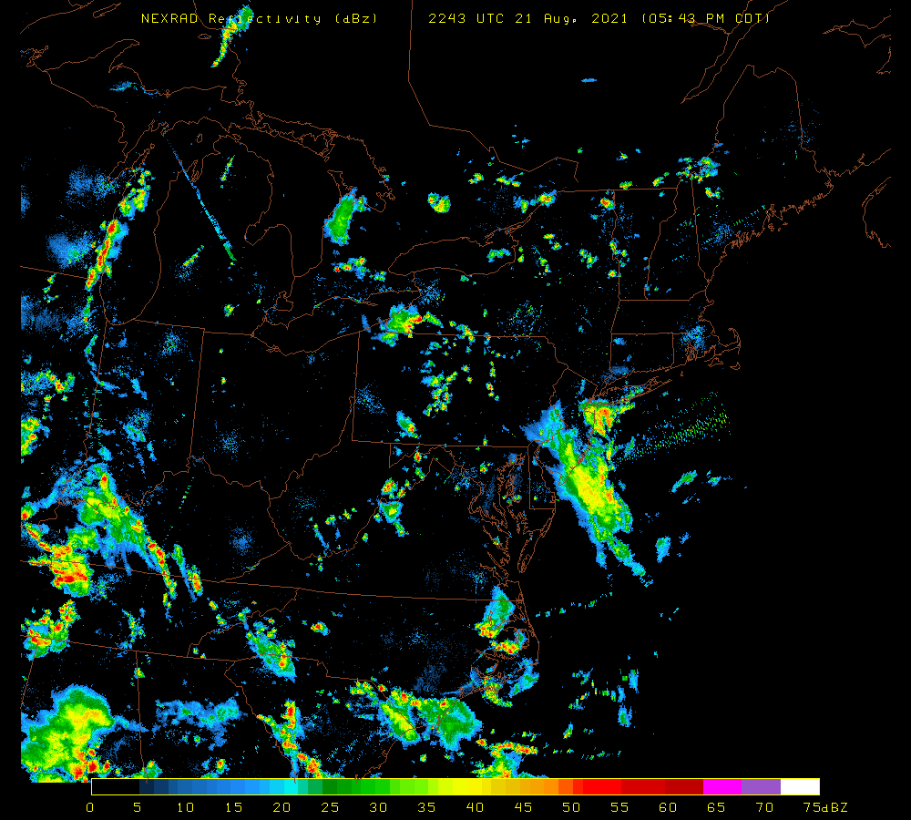 Tropical Rainstorm Fred is coming to our area later today and into late this evening. What does this mean for us?
After this system pulls away tonight some slightly less humid air will enter our area. It will still be humid, but it will feel better by comparison. Still a chance for a shower Thu and Fri but not too excited about widespread activity. Then Hurricane to be Henri tries to come west. It should stall and then move north off the east coast. An upper level system may steer it into New England this weekend, and syphon some moisture back into our area in the form of showers/storms. A little tricky but possible. It will stay mild and basically humid (typical summer). Details: Today: Showers and storms becoming likely. Torrential downpours. Very humid. 78. Thursday: Sun and clouds. Little less humid. Chance for a shower. 80. Friday: Sun and clouds. Chance for a shower. 82. Saturday: Partly sunny. chance for showers or a storm. 84. Sunday: Partly to mostly sunny. Chance for shower/storm. 84. Monday: Partly to mostly sunny. 85. Tuesday: Partly to mostly sunny. 88. Enjoy. A beautiful week looks to be upon us (for the most part). Sunshine, some clouds, slight chance of a shower Thu and then a big warm up for the weekend.
High pressure will dominate for Mon into Thursday. This will allow for mostly sunny skies. The only exception would be Tue as a wave of low pressure moves SE of our area off the east coast. This will bring some added clouds, but it will remain dry. It will clear off again Tue night/Wed morning. A stronger area of low pressure will move NE along the coast also, and this should remain to our east, but it wouldn't take much to bring some showers into our area. So there will be a chance on Thu. Right now I think the bulk will be east of our area, but some uncertainty it there. Friday, Saturday and next Sunday look nice with warming temps. 90s possible by Sun and into the following Mon/Tue. Details: Monday: Mostly sunny. 76. Tuesday: Partly sunny. 76. Wednesday: Becoming mostly sunny. 78. Thursday: Partly sunny to mostly cloudy. Chance for a shower or two. 79. Friday: Becoming mostly sunny. 84. Saturday: Mostly sunny. 87. Sunday: Mostly sunny. Humid. 90. Enjoy. The final days of July are here. And the weather will be typical summer like for the most part. Warm, humid, showers/storms then cooler. In fact, a gorgeous Fri and Sat look to be coming. Sunday won't be half bad to start. The next week does not look real wet or hot.
A frontal boundary is draped across the state. Warm and humid to the south, and then somewhat cooler to the north. Not a lot of storms or showers along it but that may change tonight as energy moves in from the west pushing the front back NE. Showers and maybe a storm or two may erupt overnight. Thursday looks active with showers and storms likely to be around. Perhaps mutilple rounds. Some heavy rain and strong gusty winds are possible. Friday and Saturday look good as does the start to Sunday. A new front will move through on Sunday evening. Could be some widespread showers/storms Sunday night. More cool air invades the region for early and mid week. Details: Wednesday: Mostly sunny. Slight chance for a shower. Humid. 86. Thursday: Mostly cloudy to partly sunny. Humid. Showers/storms. 80. Friday: Mostly sunny. Cooler. Breezy. 78. Saturday: Mostly sunny. Pleasant. 76. Sunday: Mostly sunny then cloudy with showers/storms possible late. 77. Monday: Sun and clouds. Cooler. 75. Tuesday: Partly sunny. 76. Enjoy. Hard to believe July is coming to a close in a week. Summer is moving along fast and a month from now school begins again. Enjoy the next 4 weeks or so that you have.
A nice cry comfortable stretch of weather is upon us. And it looks to come to an end starting Sunday as a warm front moves through Sat night/Sunday morning with some showers or even a rumble of thunder is possible. Then a cold front tries to move SE in the afternoon bringing more storms with it. How widespread? Uncertain. But some could be heavy. Monday Looks warm. Humid. Maybe a shower. Tuesday looks dry but hotter. Wednesday and Thursday are the question marks. Not certain how fast that system will move, but earlier is probably better. Some of the storms with this system could be quite strong to severe. Then the front may try to move back north over the next weekend bringing showers and storms with it. Overall, no soaking rains, no droughts, no heat waves, and no cold waves either. in other worlds, typical July weather: warm, humid, chance for shower/storm. Details: Saturday: Mostly sunny. Nice. 82. Sunday: Clouds w/ very early showers, then partial sun. Humid. Shower/storm late. 86. Monday: Mostly sunny. Warm. Humid. Slight chance for a shower/storm. 87. Tuesday: Mostly sunny. Humid. 90. Wednesday: Mostly sunny. Humid. Showers/storms likely. 88. Thursday: Sun and clouds. Breezy. Shower/storm possible. 80. Friday: Mostly sunny. Less humid. Cooler. 78. Enjoy Stormy Saturday then a less humid break for the upcoming week. Yes, next week looks active, yet cooler and less humid for the most part.
Potentially wet days upcoming: Saturday, Tuesday, Thu and Fri. Sun, Mon, and Wed look good and less humid. For today, a slow moving cold front will move SE across the area. The important point here is SLOW. This means the movement of storms and showers will also be slow. Thus the threat for very heavy rains is elevated. This past week several locales in the state have experienced flash flooding. There will likely be some again today, esp. to our north and east. Once the fog burns off the sun will shine with some clouds and it will get hot again as temps rise to 90 or so. Showers/storms should develop after 2 pm and should clear the area by 9 pm. Sunday looks cooler, becoming less humid, but a slight chance for a shower still exists with sun and clouds. Monday is looking nice. Tuesday a new front drops SE with showers and storms likely. Wed looks nice. Thu and Fri could be wetter as warmer air tries to move back in but cooler air tries to hold it back. Details: Today: Sunny early. Hot. Humid. Showers/storms with heavy rains after 2 pm. 90. Sunday: Partly sunny. Becoming less humid. Chance for brief shower. 78. Monday: Partly to mostly sunny. 85. Tuesday: Mostly sunny then showers/storms likely. More humid. 86. Wednesday: Partly to mostly sunny. 78. Thursday: Sun and clouds. Chance for shower/storm late. 78. Friday: Sun and clouds. Chance for showers/storms. 80 Saturday: Sun and clouds. Chance for showers/storms. 82. Enjoy. |
AuthorPastor Terry. He received his bachelors degree in Meteorology from the State University of New York at Oneonta, in 1994. The education continued as a hobby by reading the blogs of some of the best forecasters in the business. Although forceasting the weather is an imperfect science, it is a pleasure to follow what the Creator has made. Categories |
 RSS Feed